This is an update to my previous blog Ontario’s Smog Advisory: Expanded to Include City of Ottawa & Vicinity May 20, 2012.
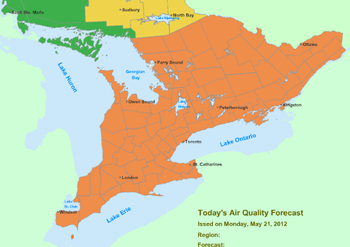
Effective immediately, the Ministry of the Environment has lifted its Smog Advisory for the following forecast regions of northern Ontario :
- Elliot Lake-Ranger Lake
- Greater Sudbury and Vicinity
- Manitoulin-Northshore-Killarney
- North Bay-West Nipissing
- Sault Ste. Marie-Superior East
The following Air Quality Index (AQI) Categories are shown in this Air Quality Forecast map:
| AQI | Colour |
|---|
| 16-31 Good | |
| 32-49 Moderate | |
| 50-99 Poor |

However, a Smog Advisory remains in effect for:
- Algonquin
- Bancroft-Bon Echo
- Barrie-Orillia-Midland
- Belleville-Quinte-Northumberland
- Brockville-Leeds and Grenville
- Burk’s Falls Bayfield Inlet
- City of Hamilton
- City of Ottawa
- City of Toronto
- Cornwall-Morrisburg
- Dufferin-Innisfil
- Dunnville-Caledonia-Haldimand
- Elgin
- Grey-Bruce
- Haliburton
- Halton-Peel
- Huron-Perth
- Kingston-Prince Edward
- London-Middlesex
- Niagara
- Oxford-Brant
- Parry Sound-Muskoka-Huntsville
- Peterborough-Kawartha Lakes
- Prescott and Russell
- Renfrew-Pembroke-Barry’s Bay
- Sarnia-Lambton
- Simcoe-Delhi-Norfolk
- Smiths Falls-Lanark-Sharbot Lake
- Stirling-Tweed-South Frontenac
- Waterloo-Wellington
- Windsor-Essex-Chatham-Kent
- York-Durham
A cold front moving across northern Ontario is causing cloudiness, scattered precipitation, and improving air quality in northern Ontario.
This smog advisory will remain in effect for the above regions of southern, central, and eastern Ontario until further notice.
The details of the smog and weather forecast for today and the next few days are as follows:
- Today, May 21:
- A low pressure system, currently just north of Sault Ste. Marie with a cold front stretching southward from the low over Michigan, combined with a high pressure ridge southeast of the province, are resulting in
- mainly sunny skies
- and south to southwesterly winds ahead of the front
- As a result, air quality indices are expected to reach the poor category across all Ontario forecast regions:
- Cloudiness
- precipitation
- and potential thunderstorms are expected in the vicinity of the front
- with northerly winds and partly cloudy skies behind the front.
- The front is forecast to move southeastward across the province later today
- A low pressure system, currently just north of Sault Ste. Marie with a cold front stretching southward from the low over Michigan, combined with a high pressure ridge southeast of the province, are resulting in
- Tomorrow, May 22
- Then by tomorrow morning:
- the front is forecast to lie over eastern Ontario
- air quality indices may reach the moderate category in eastern Ontario ahead of the cold front, as a result of fine particulate matter
- By tomorrow afternoon, a high pressure ridge is forecast to spread across southern Ontario, causing
- light winds and mainly sunny skies
- under these conditions, good to moderate air quality is expected in southern Ontario
- Then by tomorrow morning:
- Wednesday, May 23
- a low pressure system is forecast to move northeastward over northwestern Ontario, causing
- partly cloudy skies
- and light winds becoming southerly
- these conditions are forecast to produce good to moderate air quality across the province
- a low pressure system is forecast to move northeastward over northwestern Ontario, causing
For more information:
- Check out the Air Quality Index or AQI in your area.
- To help combat smog, here’s what you can do to spare the air.
- Learn more about air quality.
————————————
You may also want to know:
